Post SEO title
The Highest Mountains in the UK to Climb | Beyonk Blog
Meta description
Read on to discover the highest mountains in the UK, classifications and terminology so you can easily plan your next hill walk.
Read on to discover the highest mountains in the UK, classifications and terminology so you can plan your next hill walk, or just win your next pub general knowledge quiz.
Find your next Outdoor Activities Near You
First off, how do you define a mountain? It is generally considered to be a natural elevation rising to a summit, attaining an altitude greater than 1,969 feet (600m), and with a prominence of at least 98 feet (30m) above the surrounding landscape in all directions, according to the Simms classification.
Scotland is the most mountainous country in the UK with the most peaks in the Highlands, the area north and west of the Highland Boundary Fault. The highest peaks in England are clustered around the Lake District, again in the northwest of the country, while Snowdonia National Park has the highest peaks in Wales.
When taken as separate countries, the highest mountains in the UK are as follows:
- The highest mountain in Scotland, and also the highest in mainland UK, is Ben Nevis at 4,411 feet (1345m).
- The highest mountain in Wales is Snowdon at 3,560 feet (1085m) in the northwest county of Gwynedd.
- England’s highest mountain is Scafell Pike, at 3,209 feet (978m) and is located in the Lake District National Park in Cumbria, northwest England.
- Northern Ireland’s highest mountain is Slieve Donard at 2,789 feet (850m). Located in the Mourne Mountains, about 33 miles south of Belfast, it is the 7th highest mountain in Ireland as a whole.
However, if you include all the British territories, Mount Hope in the British Antarctic Territory wins as Britain’s highest mountain at 10,626 feet (3239m). It was only in 2017 that Mount Hope’s true elevation was measured using GPS and it officially became Britain’s highest peak. However, compared to Mount Everest in the Himalayas at 29,028 feet (8848m) and Mont Blanc in the French-Italian Alps at 15,781 feet (4810m), nothing in the UK even comes close.
Highest Mountains in the UK Map
The map shows the highest mountains in the UK over 600m. Click on the icons to see the names and height in meters and feet.
Other helpful mountain resources
Read on to learn about the highest mountains in the UK.
Highest Mountains in the UK in Order and Routes to Climb them
This list of the top 10 highest mountains in the UK in order, is listed by overall height. They are all in Scotland and are all Munros.
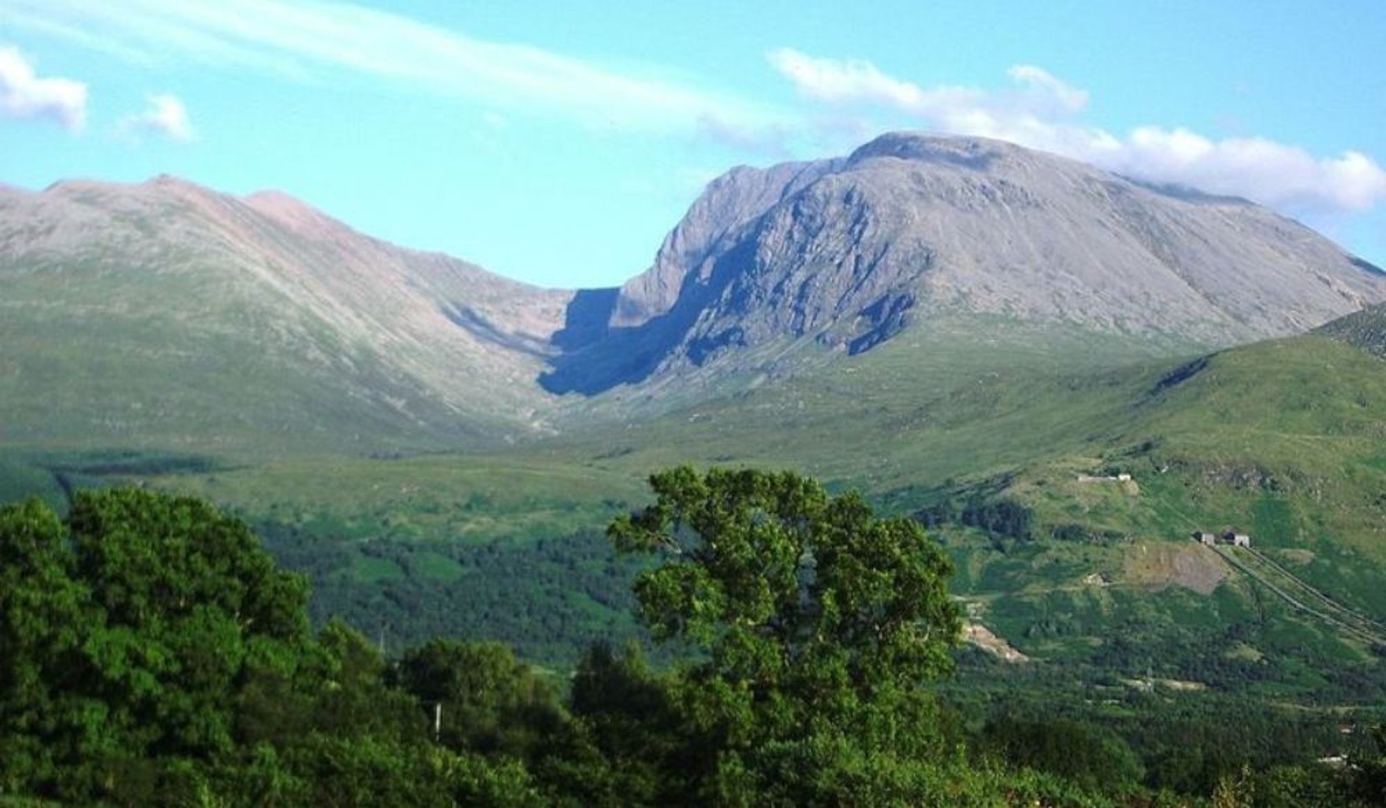
Ben Nevis – 4411 ft (1345m)
The highest peak in Scotland and in the UK, Ben Nevis is near Fort William, at the western end of the Grampians in northwest Scotland. It attracts over 100,000 walkers who mostly ascend using the Pony Track route from Glen Nevis. The north face cliffs are one of the toughest challenges for mountaineers and ice climbers. The summit, a volcanic caldera, still has ruins of the meteorological observatory that operated from 1883 to 1904.

Ben Macdui – 4,295 ft (1309m)
Britain’s second highest peak is Ben Macdui in the Scottish Highlands. It is the highest peak in the Cairngorms National Park which is the largest national park in the UK covering over 1,700 square miles. The easiest ascent is a 4 mile route starting from the Cairngorm Ski Centre. A detour can be included to “bag” Cairn Gorm along the way. Other routes are possible but all involve a slow and steady trek. One option is to cycle from the Linn of Dee to Derry Lodge (about 2.5 miles) and then ascend the southern side. The summit with its bare boulder field has a toposcope identifying the surrounding mountains, erected in 1925.

Braeriach – 4,252 ft (1296m)
Located in the western massif of the Cairngorms, Braeriach is known for its corries which harbour year-round snow pockets. Most walkers ascend Braeriach from the Sugar Bowl car park near the Cairn Gorm ski area and the arduous walk is 5.6 miles each way. The path navigates the steep-side ravine of Chalamain Gap and Lairig Ghru Pass before reaching the summit.

Cairn Toul – 4,236 ft (1291m)
Cairn Toul is linked by a mountain pass to Braeriach and towers above the western side of Lairig Ghru Pass. Due to its location, Cairn Toul is often climbed in conjunction with other neighbouring peaks including The Devils; Point, Braeriach and Sgor an Lochain Uaine. It necessitates a long trip, often over two days and may entail a stay at the isolated Corrour Bothy refuge overnight. The ascent includes all types of terrain from scree and boulder fields to boggy areas.

Sgor an Lochain Uaine – 4,127 feet (1258m)
Located in the Cairngorms, Sgor an Lochain Uaine is a remote peak often ascended along with other peaks. From the north, walkers must first ascend Braeriach and from the south the route includes Cairn Toul and Devil’s Point. It has a small loch on the northeast side of the summit and its name appropriately means “Peak of the Little Green Loch”.

Cairn Gorm – 4,084 ft (1245m)
Set in the Scottish Highlands overlooking the ski resort and town of Aviemore, Cairn Gorm gives its name to the whole range of mountains. The northwest slopes are used for downhill skiing in winter and they are served by the funicular Cairngorm Mountain Railway, the highest railway in the UK. The one mile line ends at the Ptarmigan building some 1087m up Cairn Gorm. Most ascents are on the north side although high winds and blizzards can make it impassable. The summit houses an automated weather station transmitting wind speed and temperature data. Look for the remote Loch Avon from the southern side of the summit.

Aonach Beag – 4,049 ft (1234m)
Close to Fort William and just 2 miles east of Ben Nevis, Aonach Beag is connected to Aonach Mor by a mountain pass or high saddle. The easiest ascent starts by taking the gondola lift on Aonach Mor to 650m and then walk along the ridge joining the twin peaks. It can also be climbed in more isolated conditions from Glen Nevis to the south. The north face of Aonach Beag has one of the longest existing snow patches at the bottom of the Queens View climb at a height of 950m.

Aonach Mor – 4,006 ft (1,221m)
Aonach Mor is popular for skiing and snowboarding and in summer the gondola ski lift is used by hikers, paragliders and mountain bikers wanting to descend the downhill mountain bike track. The mountain hosts the Mountain Bike World Cup and other championships. Climbers can use the ski gondola for the first ascent of 2,100 ft (650m) and then walk to the summit. Aonach Mor can also be tackled from the south side. Most walkers also ascend Aonach Berg via the high bealach (pass).

Carn Mor Dearg – 4,006ft (1,221m)
Connected to Ben Nevis via the spectacular Carn Mor Dearg Arête, Carn Mor Searg is the 8th highest mountain in the UK. It offers an excellent horseshoe route starting from the North Face car park, traversing the arête and then descending to the CIC Hut. In good conditions, climbers can reach the summit from the ski area in two hours.

Ben Lawers – 3,983 ft (1214m)
Ben Lawers is the highest peak in Perthshire. It is on the watershed between the Tay and Lyon Rivers and water is channelled into the Breadalbane Hydro-Electric Power Station. The mountain is a National Nature Reserve and has an exceptional diversity of artic-alpine plants and flora including alpine forget-me-not and saxifrages. There is a National Trust car park on the western side and a path leads to the summit. The lower section of the path is a nature trail and the path ascend to the summit of Ben Lawers via the Beinn Ghlas peak. Alternative routes follow Lawers Burn and the east ridge. There's also an event that occurs here once each year, called the Artemis Kindrochit Great Quadrathlon that involves running 15 miles across 7 peaks with a swim, bike and kayak thrown in for good measure!

Different types categories of the Highest Mountains in the UK
According to the International Climbing and Mountaineering Federation, height and prominence are the most important factors when comparing mountains. While some of the tallest mountains in terms of overall size start on the seabed, other summits are a mere bump on the side of another mountain. We will be listing the highest mountains in the UK by height. Anything below 2,000 feet or 609m is considered a hill.
Some classifications of mountains are often grouped together for different purposes. For example, “Munro bagging” involves climbing all the mountains in Scotland over 3000 feet (914.4m). It’s a lifelong challenge to climb them all and achieve the kudos as a “Munroist”.
Here are the definitions of some of the main mountain classifications in the UK:
The P600s (the Majors)
P600s are mountains anywhere in the British Isles with a prominence above 1,969 feet (600m) regardless of the overall height of the mountain. There are 120 P600s; 81 in Scotland, 25 in Ireland (just 1 in Northern Ireland), 8 in Wales and 4 in England.
Hewitts
Hewitt is the acronym for Hills in England, Wales and Ireland over Two Thousand feet. They must have a relative height of 98 feet (30m). The latest list (2019) has 525 Hewitts: 209 in Ireland, 180 in England and 136 in Wales.
Simms
Simms are “metric Hewitts” and the list was devised in 2010. They need to be at least 1,968 feet (600m) in height and have a minimum prominence of 98.4 feet (30m). Using this definition, there are 2,754 Simms in the British Isles. This list is maintained by the DoBIH – the Database of British and Irish Hills
Nuttalls
Compiled in 1989 by avid mountain walkers John and Anne Nuttall, Nuttalls are mountains in England and Wales only. They must be over 2,000 feet (610m) with a relative height of 49 feet (15m) so they include many smaller tops than other classes. There are 444 Nuttalls.
Munros
There are 282 Munros. These are peaks in Scotland exceeding 3,000 feet or 914.4m. There is no set prominence, but Munros must be seen as a separate mountain. This list was compiled in 1891 by Scottish mountaineer Sir Hugh Munro. Subsidiary summits are called Munro Tops, of which there are 227.
Murdos
Murdos are any Munro in Scotland (over 3,000 feet or 914.4m high) with a prominence of at least 98 feet (30m). There are 442 Murdos.
Furths
Furths have the same criteria as Scottish Munros but are located elsewhere in the British Isles. There are 34 Furths: 15 in Wales, 13 in Ireland and 6 in England.
Corbetts
The Corbetts only include mountains in Scotland which are between 2500 and 3000 feet (762 and 914.4m) with a prominence of at least 55 feet (152m). There are currently 221 Corbetts on the list, which is maintained by the Scottish Mountaineering Club.
Grahams
The next lowest group is the Grahams, Scottish mountains between 2000 and 2500 feet (609.6 and 762m). The updated list has 221 Grahams.
Donalds
Donalds are hills in the Scottish Lowlands exceeding 2000 feet (609.6m). It includes 89 summits and 51 subsidiary tops.
Marilyns
There are 1216 Marilyns in Scotland. These are hills with a relative height of 492 feet (150m) above their surroundings regardless of their total height.
HuMPs
HuMPs were devised and published by Mark Jackson as recently as 2010. HuMPs are the acronym for “Hundred and Upwards Metre Prominence” mountains. Similar to Scottish Marilyns, HuMPs are mountains of any height with a prominence of 330 feet (100m). There are 2,986 HuMPs in the British Isles: 2,168 in Scotland, 833 in Ireland, 444 in England, 366 in Wales and 11 in the Channel Islands.
TuMPs
Mark Jackson produced another classification of mountains in 2010, known as TuMPs (Thirty and Upwards Metre Prominence). This covers all hills and mountains in Britain that stand at least 98 feet (30m) above the surrounding land on all sides. Not surprisingly, this is an extensive list with 17,044 named TuMPs. The list is now maintained by the Database of British and Irish Hills.
These are the main classifications of mountains in the British Isles, but there are others. These different classifications create very different rankings for mountains. For example, Scafell Pike is the highest mountain in England, but only the 257th highest in the British Isles as per Simms. It is 138th on the Marilyn classification and the 46th highest mountain on the P600. As with many other mountains, Scafell Pike is included in various classifications as a Marilyn, HuMP, Furth, Hewitt and a Nuttall. It is often the prominence of a mountain summit, as well as the height, that defines its classification.
List of the Highest Mountains in the UK
Below is a list of the highest mountains in order of elevation.
UK's Highest Mountain #1: Ben Nevis. Country: Scotland. Height: 1345 meters and 4437 feet.
UK's Highest Mountain #2: Ben Macdui. Country: Scotland. Height: 1309 meters and 4320 feet.
UK's Highest Mountain #3: Braeriach. Country: Scotland. Height: 1296 meters and 4277 feet.
UK's Highest Mountain #4: Ben Lawers. Country: Scotland. Height: 1214 meters and 4006 feet.
UK's Highest Mountain #5: Beinn a'Bhuird. Country: Scotland. Height: 1197 meters and 3950 feet.
UK's Highest Mountain #6: Carn Eige. Country: Scotland. Height: 1183 meters and 3904 feet.
UK's Highest Mountain #7: Stob Choire Claurigh. Country: Scotland. Height: 1177 meters and 3884 feet.
UK's Highest Mountain #8: Ben More. Country: Scotland. Height: 1174 meters and 3874 feet.
UK's Highest Mountain #9: Lochnagar - Cac Carn Beag. Country: Scotland. Height: 1156 meters and 3815 feet.
UK's Highest Mountain #10: Sgurr na Lapaich. Country: Scotland. Height: 1151 meters and 3798 feet.
UK's Highest Mountain #11: Bidean nam Bian. Country: Scotland. Height: 1149 meters and 3793 feet.
UK's Highest Mountain #12: Ben Alder. Country: Scotland. Height: 1148 meters and 3788 feet.
UK's Highest Mountain #13: Ben Lui. Country: Scotland. Height: 1130 meters and 3729 feet.
UK's Highest Mountain #14: Binnein Mor. Country: Scotland. Height: 1130 meters and 3729 feet.
UK's Highest Mountain #15: Creag Meagaidh. Country: Scotland. Height: 1128 meters and 3722 feet.
UK's Highest Mountain #16: Ben Cruachan. Country: Scotland. Height: 1127 meters and 3719 feet.
